Teeth of the storm
A distant rumble woke me and for a while I lay listening to the sound of rain hammering against the flysheet. The wind tore at the foot of the tent and occasionally a distant lightning flash would cast a pale light across Alan’s slumbering form. Images of the previous evening flooded my mind: the feeling of snow melting on my bare legs as we stared at the thawing ice bridge; the desolate calm as our eyes probed the impenetrable mist…
From the ridge we had descended snow fields, sliding on our soles over the even contours, propelled forwards by our walking poles, carefree and happy as we playfully mimicked the poise and motion of down hill skiers.
Between each stretch of hard-packed snow lay rough, rocky terrain, which we avoided as far as possible. Its large boulders were unsteady and unpredictable. Stepping from one to another demanded keen concentration because of the way they pivoted awkwardly. I had to tread warily to spare my knees as I negotiated the sudden drops between each rock. The snow fields, on the other hand, were smooth and easy to navigate.
Eventually both the snow fields and boulders gave way to smooth expanses of unbroken rock. It was a featureless landscape made eerie by the fog that hemmed us tightly in all around. The rocks were uniform in colour and texture, stretching out beneath us like wave after wave of clumsily poured treacle. The contours tightened as we neared the edge of one flow, before the ground abruptly levelled out as we stepped onto the next.
An extravagance of cairns marked a thousand possible routes. It was impossible to tell which ones marked the way down and which were merely decorative. Everyone who walks there must build a cairn, but from what? This was not a typical rugged hillside with fresh stones being continually eroded. It was a desert of smooth, unbroken rock. To build a cairn would require persistent effort; just finding the stones would have taken me most of an afternoon. Perhaps to build a cairn here is a well known hikers’ challenge; the Spanish equivalent of jumping between Adam and Eve when you climb Tryfan in Snowdonia.
By now the temperature had plummeted. It had been merely cool when we left the ridge, but since then evening had settled over the valley. We had also become engulfed in the cold, dense clouds that surged over the Maladeta range to our left in a continual tide, tumbling to the valley floor, displacing the sun-warmed air and obscuring our view. As the weather deteriorated we had become increasingly reluctant to stop, forsaking rest in the expectation that a campsite was not far ahead. So, despite the cold, we were still tumbling along in our shorts.
Time and again, the line of cairns fanned out, offering an abundance of possible routes. We followed the largest cairns, wherever we could actually discern a difference in size, or stuck close to the river, which offered a more definite point of reference.
Then abruptly, we were stopped by a raging torrent. It surged across our path before plunging sharply over a waterfall into a gorge to our left, which fed into the main river. The line of cairns continued on the opposite side, tauntingly obvious, as if there were no obstacle in our path. Scanning around, we spotted a narrow ice bridge. It lay downstream, beyond the waterfall, over the deepest part of the gorge, just before the obstructing tributary merged with the river we had been following.
During the winter months the gorge would have been full of snow. Spring melt water would have run along the bottom of the gorge, eroding the snow from beneath and leaving a ceiling of snow which would cave in bit by bit as the weather grew warmer. The bridge was the only surviving segment of this ceiling. It could be formed from hard packed ice that would bear our weight, or it might be all but thawed and ready to collapse. The only way to find out was to walk across it. But if it fell, we would drop forty feet to the swollen torrent surging through the gorge.
On a sunny day it would probably have been easy enough to scramble down the face of the gorge, hop nimbly across the stream and continue on the other side. But today, the tributary was a storm water engorged torrent. We had only one choice: turn into the wind and follow the gorge to a suitable crossing point.
Without a word, we nodded agreement and shrugged off our packs. I only intended to put on my waterproof trousers and, perhaps, a fleece jacket but once my hands were inside my pack there seemed to be no end to the warm clothing I pulled out. I was acting on instinct, a tired, cold body protecting itself against the raging elements. Experience, reflex and habit acted together more effectively than intellect.
Soon afterwards, we clipped the hoods of our rucksacks closed and gave each other an appraising glance. Then, transformed from summer hill-walkers caught out in a wintry storm into rugged men of the mountains, resolved and resilient inside our weatherproof shells, we turned into the wind.
A short way upstream, the tributary spilt out across one of the characteristic flat areas. The rock was slippery and the water washed high up the sides of our gaiters as we moved cautiously through the current. But once clear of the rocks a steep snowfield provided an easy slide down beneath the ice-bridge and beyond to safer terrain.
Soon afterwards we picked up the traces of a path, feeling its way down sudden crags before sweeping through undulating stretches of turf. The contours resembled a pitch and putt course, littered with shallow pools in place of bunkers. Each level grassy section seemed to offer a generous selection of campsites but each in turn proved too water logged to even stand on. Eventually, as dusk faded into darkness, we chanced upon a narrow grassy shelf raised above a swollen brook. It was both close enough to the brook and high enough above it to be reasonably well drained.
As we pushed the last tent pegs home, the rain called time-out and we were able to fetch water, cook and arrange our sleeping space before the first heavy drops began to fall again.
We retreated into the tent with plates of steaming food and hot drinks as hail stones rattled into the abandoned cooking pots. Eating lying down is far from easy but it had a curious benefit; after hungrily emptying our plates, we were able to scavenge a sizeable second helping from the hoods of our sleeping bags.
Links to other chapters:
Chapter 1: Pyrenean foothills, please; one way
Chapter 2: Lovers and fishermen
Chapter 3: Visions and vistas
Chapter 4: Shattered dreams
Chapter 5: The mountain gods
Chapter 6: Catching the drips
Chapter 7: Ghosts on the col
Chapter 8: Teeth of the storm
Chapter 9: Stealing the solitude
Chapter 10: Voulez vous!
Chapter 11: The yellow goblin
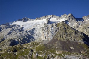
Maladeta range, below which we camped
Wikimedia photo, reproduced under Creative Commons licence
Recommended reading
Long distance walks in the Pyrenees
The guide book used by the Backpacker Diaries author. It is one of a series of trekking guides from Chris Townsend, which cover mountain ranges on several continents. It is currently out of print but copies are available via the link below.
Walks & climbs in the Pyrenees
Since the first edition in 1978, this book has become the authoritative guide to the range. The new edition incorporates many revisions and includes more than 170 day walks, multi-day walks, climbing routes and mountaineering ascents.
The Pyrenees
A resource book covering the finest walks, treks and climbs in the High Pyrenees from the Cirque de Lescun, on the edge of the Basque country in the west, to the Carlit massif and the Cerdagne to the east of Andorra.
Through the Spanish Pyrenees: GR11
The GR11 is a high-level mountain trail following tracks and footpaths. Affectionately known as "La Senda" (The Track), it crosses the Pyrenees from coast to coast on the Spanish side of the border.
Chapter 8 image 2