Ghosts on the col
The former desolation became complete as we left behind the last traces of water and vegetation and tackled the first of a long series of scrambles that would soon land us upon the ridge. All around us, the barren landscape was littered with unnerving testaments to previous human presence.
Small stone enclosures about a foot high, oblong and the size of coffins adorned every level site on the rolling expanse of bare rock. Were they bivouac sites built by hikers stranded at this high altitude? Perhaps we were passing through the final resting place of an ancient people? Who had built these enclosures, for who and why? The mist left ghostly trails between them, swooping into one stone resting place then darting away, dispersing and reappearing elsewhere. There was a chill in the air; we hurried on.
The final push to the ridge was a strenuous slog. We balanced across large boulders to reach a final short but exposed scramble, after which we were able to haul ourselves onto the knife-edge rim. To the west, the Aneto range lay hidden behind mist. Our route down led north across a snowfield and Tuc de Mulleres surged above us just 100m to the south.
At 3010m, it is the highest point on the Salencas range. Abandoning our packs we hopped nimbly over a rough tumble of unstable boulders to the summit. A visitors’ book chained to the simple iron cross indicated that no-one had been there for two days – the last entry boasted of sun.
But for us, the weather had not improved since morning. There was no view so we enjoyed a brief feeling of 3000m high elation before hurrying back to our packs to start the descent.
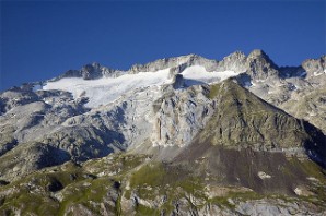
Pico de Aneto ridge, which towered unseen above us during our headlong dash.
Wikimedia photo, reproduced under Creative Commons licence
Two hours later the weather was deteriorating fast. The storm was closing in for a full blown nocturnal assault and we were still a good distance from any potential camping ground. The temperature was falling fast, rain was turning to snow and the daylight was almost gone.
We had lost enough height to give us a fighting chance against the lightning, except for the ice axes strapped to our packs. Their metallic points jutted skywards, more or less daring the electric charge to choose us as a route to the ground.
We had no intention of ending our trip prematurely, and certainly not on the end of ten million volt lightning bolt - not when there was a beach in Barcelona to look forward to. So we made a headlong dash down the valley. Pico de Aneto rose formidably above us to the left, but we did not see, look or even think of it; our only interest was survival.
Our food intake had been low for several days and we were dependent for nourishment on our hot, evening meal. If we allowed ourselves to be exposed like this for long we would become hypothermic. We needed to reach the lower meadows, where we could pitch the tent, cook and retreat to the protective warmth of our sleeping bags.
The early evening of that day turned out to be a rigorous endurance test. As we set up camp a few hours later, we recalled the rock enclosures, which seemed more than ever to be a sombre reminder of just how effortlessly the mountains can snatch away unwary intruders.
But not us, at least not today. A short time later, with our hot meal eaten and sleeping bags pulled snug, sleep overwhelmed us almost immediately.
Links to other chapters:
Chapter 1: Pyrenean foothills, please; one way
Chapter 2: Lovers and fishermen
Chapter 3: Visions and vistas
Chapter 4: Shattered dreams
Chapter 5: The mountain gods
Chapter 6: Catching the drips
Chapter 7: Ghosts on the col
Chapter 8: Teeth of the storm
Chapter 9: Stealing the solitude
Chapter 10: Voulez vous!
Chapter 11: The yellow goblin
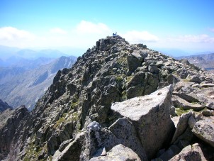
Tuc de Muleres (on a good day)
Hey, that's my photo! See message on the Pyrenees home page
Recommended reading
Long distance walks in the Pyrenees
The guide book used by the Backpacker Diaries author. It is one of a series of trekking guides from Chris Townsend, which cover mountain ranges on several continents. It is currently out of print but copies are available via the link below.
Walks & climbs in the Pyrenees
Since the first edition in 1978, this book has become the authoritative guide to the range. The new edition incorporates many revisions and includes more than 170 day walks, multi-day walks, climbing routes and mountaineering ascents.
The Pyrenees
A resource book covering the finest walks, treks and climbs in the High Pyrenees from the Cirque de Lescun, on the edge of the Basque country in the west, to the Carlit massif and the Cerdagne to the east of Andorra.
Through the Spanish Pyrenees: GR11
The GR11 is a high-level mountain trail following tracks and footpaths. Affectionately known as "La Senda" (The Track), it crosses the Pyrenees from coast to coast on the Spanish side of the border.
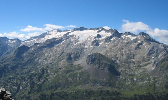
Maladeta range, below which we camped
Wikimedia photo, reproduced under Creative Commons licence